Winter Storm Warning and Weather Advisory for Heavy Snow Through Tuesday in Northern Chicago Area
The portion of the Chicago area north of Interstate-80 is under a combination of a Winter Storm Warning (pink-shaded area on maps above and below) and Winter Weather Advisory (purple-shaded area on maps above and below calling for 2 to 6-inches of wet heavy snow later this Monday night and Tuesday (9 p.m. CST this evening until 9 a.m. CST Tuesday).
Heaviest 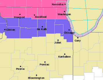

After a relatively mild day Monday, a strong cold front is forecast to push south across the Chicago area, pulling much colder air into northern Illinois. At the same time low pressure will be developing in the central plains. With the cold front becoming stationary across central Illinois, the center of low pressure is forecast to move east along the front, passing to our south Tuesday.
A rain/snow mix should develop this evening and spread east out of Iowa across northern Illinois, changing over to a heavy wet snow later tonight and continuing into Tuesday morning. Snow should gradually end from west to east later Tuesday afternoon/Tuesday evening. Depending upon how cold temperatures get and how fast rain changes over to a wet snow, a period of freezing rain will be possible in some areas later tonight.
Close-up map of the Chicago area under Winter Storm Warning (pink) and Winter Weather Advisory (purple) Tonight into Tuesday…