• Privacy Policy

News & Promotions

What's going on in your world?

  • Automotive
  • Entertainment
  • Education
  • Financial
  • Health
  • Home Builder
  • Humor & Memes
  • Insurance
  • Parenting
  • Restaurants
  • Shopping
    • Coupons
    • Special Offer
  • Sports
  • Technology
  • Travel
    • Transportation
    • Weather
  • Mobile Apps
You are here: Home / Science / A Satellite’s First Look at Earth Has a Stunning Photo of the Sahara

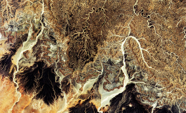
A Satellite’s First Look at Earth Has a Stunning Photo of the Sahara

July 3, 2015 By Ellen Smith

Sentinel-2A conducted its first ever scan of Earth on June 27th. The result was this gorgeous image of the Sahara in central Algeria, showing a glorious terrain of rocks and sand.

Sentinel-2 is the second of six planned Sentinel missions. A pair of satellites with multispectral high-resolution imaging systems, Sentinel 2 will be used to track land use, vegetation stress, soil and water cover, or satellite imagery for emergency response. This Sahara photo is only one of the first photos picked up by the satellite, the rest being shots of Europe.

Source: io9 A Satellite’s First Look at Earth Has a Stunning Photo of the Sahara | Image credit: Copernicus data (2015)/ESA

Filed Under: Science, World Tagged With: air port

Please Follow & Like Us :)

Facebook
Facebook
fb-share-icon
Twitter
Visit Us
Follow Me
Tweet
RSS

Recent Posts

Colonial Pipeline reportedly paid millions for slow-ass decryption software

When it comes to ransomware, you don't always get … [Read More...]

Advanced tax strategies for startup founders

Peyton Carr is a financial advisor to founders, … [Read More...]

Here’s How To Add Pronouns To Your Instagram Profile In A Few Simple Steps

Instagram is making it so much easier to share … [Read More...]

Copyright © 2023 · News & Promotions, 538 W. 21 St. #91289 Houston, TX 77008-3642 · All rights reserved · Unsubscribe · Log in

Go to mobile version